PYRAMIDAS / LABORATOIRE / Systèmes Orbitaux
Orbital background
[SYS: ONLINE]
[ORBIT: LEO / MEO / GEO]
[LINK: OPTICAL]
[DATA RATE: 18 GBPS]
[LATENCY: 12 MS]
[VIES: IPv6-FIRST]
[DEBRIS DENSITY: HIGH]
[TRACKED: 50,000+]
[KESSLER INDEX: ACTIVE]
[MMEDR: SYNCED]
[MARL: CONVERGING]
[ISAM / OOS READY]
PYRAMIDAS ADVANCED SYSTEMS — Orbital Infrastructure Lab

Orbital
Infrastructure
Visualization
& Remote Operations

Digital twins, multi-agent AI and immersive teleoperation for the next generation of autonomous orbital infrastructure.

MMEDR FrameworkMARL NavigationVIES ProtocolISAM · OOS · ADR
Scroll
ORBIT SYNC 12ms
DEBRIS TRACKED 50,247
SIGNAL LATENCY ZERO
CHASER STATUS NOMINAL
KESSLER INDEX HIGH
VIES PROTOCOL ACTIVE
HIL TELEMETRY 1000 Hz
ORBIT SYNC 12ms
DEBRIS TRACKED 50,247
SIGNAL LATENCY ZERO
CHASER STATUS NOMINAL
KESSLER INDEX HIGH
VIES PROTOCOL ACTIVE
HIL TELEMETRY 1000 Hz
140M+Debris fragments
54 000km/h impact velocity
>50kObjects tracked
12 msMMEDR sync
01Context

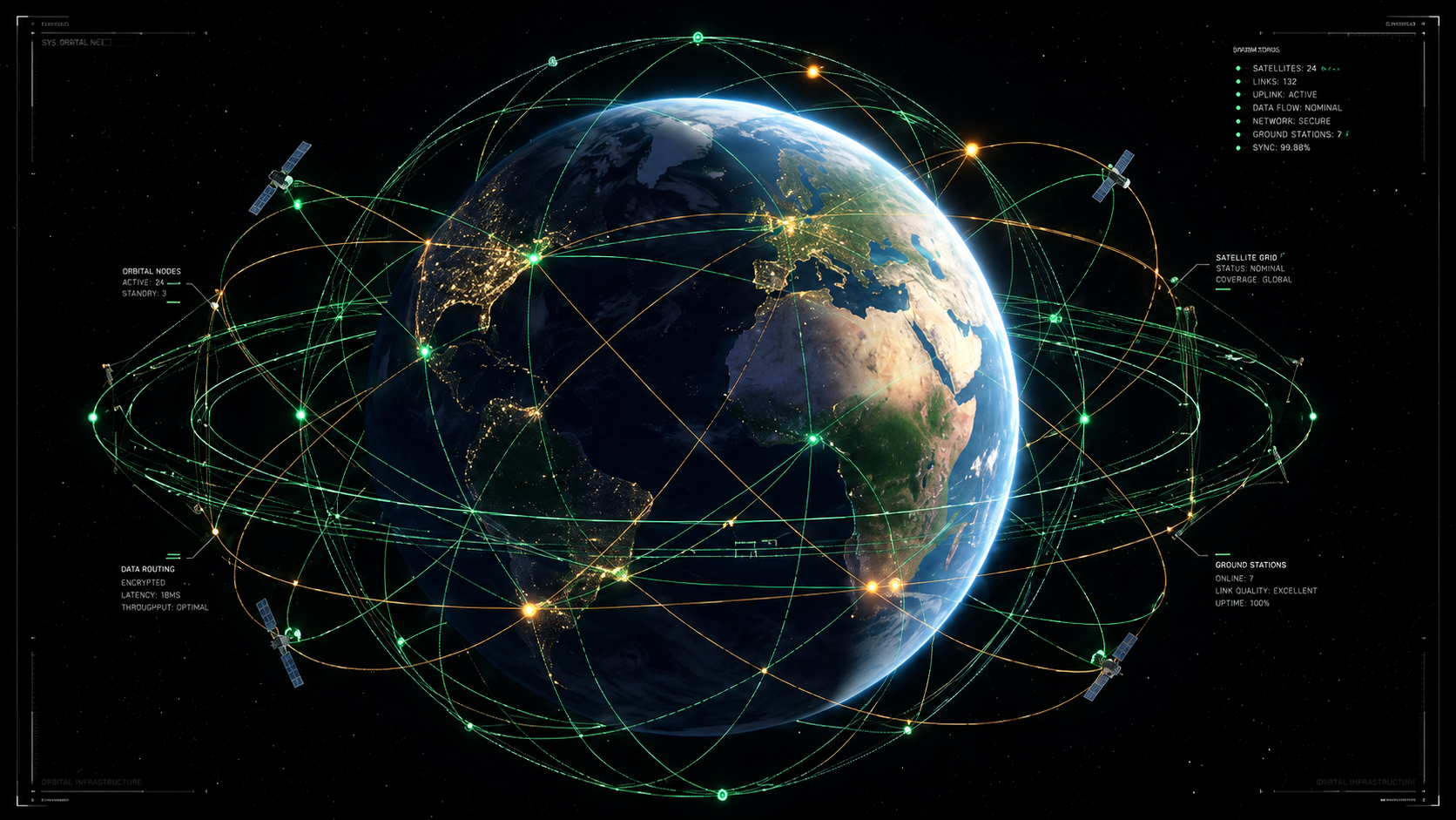
Earth orbit becomes the critical infrastructure layer of the 21st century.

The passive model — monitor, avoid, deorbit — is structurally obsolete. Pyramidas frames orbit as an active infrastructure domain: visualized, synchronized, simulated and operated through digital twins, AI agents and immersive control systems.
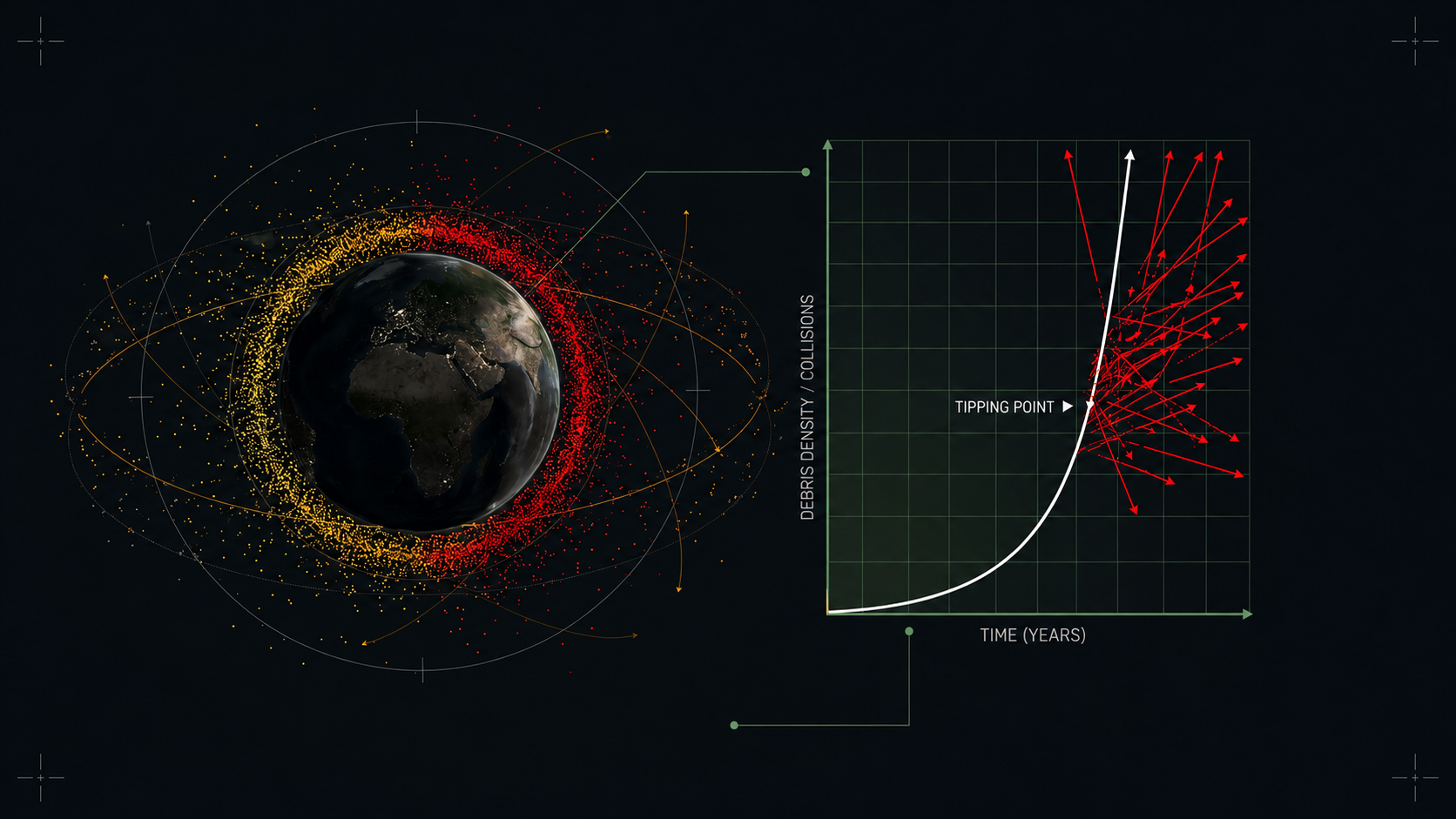
Orbital congestion has crossed a critical inflection point. Each collision creates secondary fragments, increasing future collision probability.
Orbital congestion
Visual slot: orbital-congestion-main.jpg
02 — Threat Assessment
Low Earth Orbit at the edge of the Kessler threshold.
140M+ Fragments54 000 km/hRisk Cascade
[MODULE-02]Orbital Congestion · Threat Matrix
CRITICAL
02Threat

Kessler
Syndrome Threshold

  • Micro-fragments remain largely invisible to conventional tracking networks.
  • Critical orbital bands concentrate commercial and sovereign infrastructure.
  • Impact energy turns centimeter-scale fragments into mission-ending hazards.
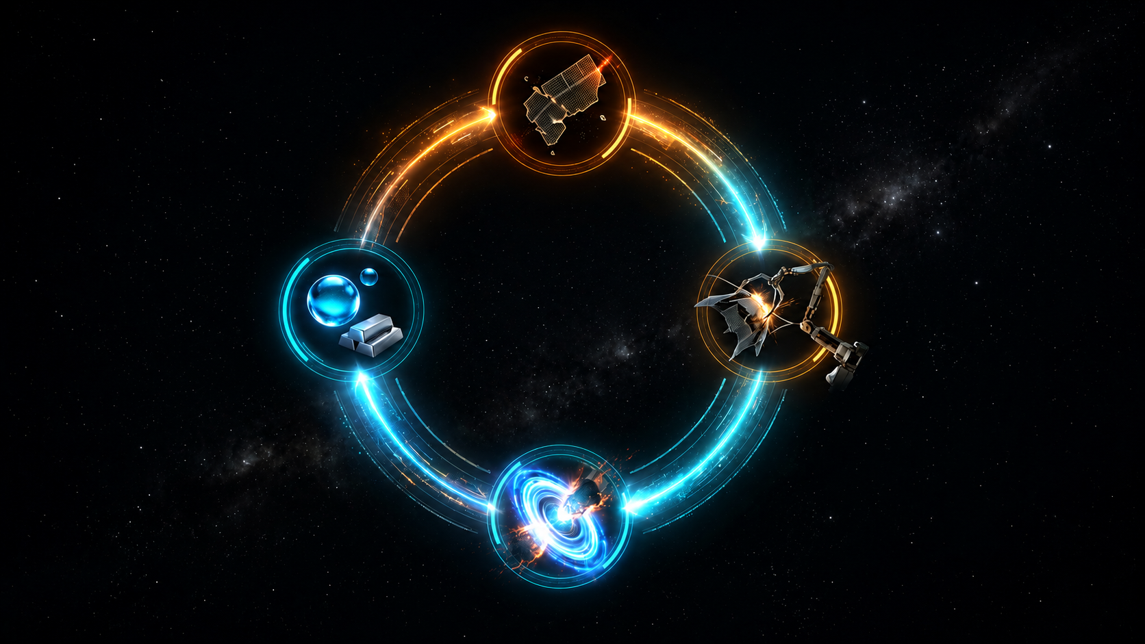
Cascade RiskLEO Critical BandSST Gap
[MODULE-03]Orbital Resource Transition · ISRU
PARADIGM SHIFT
03Resources

From kinetic risk
to orbital feedstock.

  • Active capture reframes debris removal as resource recovery.
  • ISRU logic avoids the gravity-well cost of launching every kilogram from Earth.
  • Orbital slots become cleared, maintained and monetizable infrastructure.
// Strategic InsightRemediation becomes credible when recovery offsets operational cost.
[MODULE-04]MMEDR · Digital Twin Rendezvous
SYNC ACTIVE
04Digital Twin

Physical-digital
symbiosis.

The twin does not merely observe. It simulates, predicts and validates manoeuvres before physical execution — keeping humans on the loop, not in the latency bottleneck.

// 01
Navigation
Lightweight pose estimation for constrained orbital hardware.
Nav-Net
// 02
Fusion
Sensor fusion bridges simulation and orbital conditions.
Actor-Critic
// 03
Validation
Hardware-in-the-loop telemetry validates manoeuvres.
HIL · 1000Hz
digital-twin-main.jpg
MMEDR Framework
Twin Telemetry
Sync12 ms
Position±0.1 mm
Attitude±0.05°
[MODULE-05]Remote Operations · Autonomous Rendezvous
APPROACH PHASE
remote-ops-main.jpg
Remote Ops
remote-ops-detail-01.jpg
Trajectory
Guidance
AIDDPG / D4PG
SafetyCBF Active
ProfileSlow / stable
05Remote Ops

Autonomous
chaser navigation.

  • Teleoperation layer gives operators an FPV-style mission interface.
  • AI guidance performs proximity operations against non-cooperative targets.
  • Safety constraints are hard barriers, not decorative indicators.
[MODULE-06]MARL · Cooperative Multi-Agent Coordination
POLICY CONVERGED
06AI Architecture

Cooperative
multi-agent fleet.

Single-agent navigation fails at scale. Multi-Agent Reinforcement Learning coordinates fleets of chaser vehicles while preserving collision boundaries and communication resilience.

// ADV-01
Decentralised
Agents maintain individual policies under degraded communication.
// ADV-02
Predictive
Collision boundaries are integrated at the control level.
// ADV-03
Shared Planning
Fleet decisions optimise global mission durability.
[MODULE-07]VIES · Immersive Infrastructure Layer
PROTOCOL ACTIVE
07Protocol

VIES as the
immersive infrastructure layer.

VIES is not presented here as “metaverse”. It acts as a standardised layer for distributed immersive environments, geospatial synchronization and remote operations interfaces.

  • Interoperability between physical assets, digital twins and operator interfaces.
  • Real-time layers for telemetry, geospatial states and immersive collaboration.
  • Open infrastructure logic instead of closed platform dependency.
[MODULE-08]SIGNAL / SOUFFLE · Synchronization Networks
NETWORK ONLINE
08Networks

Distributed
nervous system.

// SIGNAL
Broadcast
State events and alerts distributed without polling overhead.
One-to-many
// SOUFFLE
P2P Mesh
Heavy files, models and telemetry exchanged node-to-node.
Mesh sync
// AMARRE
Spatial Anchor
Space-time address layer linking coordinates and orbital state.
XYZ + Time
[MODULE-09]XR Mission Control · Management by Exception
SUPERVISION ACTIVE
09Mission Control

XR supervision
for critical systems.

The operator environment shifts from manual command execution to orchestral supervision. Humans define constraints, validate exceptions and manage the mission envelope.

  • 3D telemetry replaces flat dashboards for spatial decision-making.
  • AI triage prioritizes anomalies and intervention windows.
  • XR training supports simulated rehearsal before physical operations.
10Applications

Strategic
Domains

The same stack applies beyond orbit: aerospace, defense, industrial digital twins and smart infrastructures.

🛰
Space Operations

Constellation management, active debris removal, inspection and on-orbit servicing.

LEO / GEO
🔭
Defense & Sovereignty

Situational awareness, protected satellite operations and strategic simulation.

SSA · SST
Industrial Systems

Remote operation frameworks for critical facilities, grids and transport networks.

Digital Twin
🌐
Smart Infrastructure

Geospatial interfaces, XR command rooms and distributed synchronization.

VIES · XR
strategic-applications-main.jpg
Strategic Applications Visual Slot
[MODULE-11]Pyramidas Advanced Systems · Technology Stack
STACK READY
11Pyramidas

Advanced systems,
not generic 3D.

Pyramidas links real-time visualization, geospatial intelligence, digital twins, XR interfaces and AI-assisted mission design.

pyramidas-systems-main.jpg
Pyramidas Systems
// ENGINE
Unreal Engine
Real-time rendering, simulation and mission-control visuals.
// GEO
Geospatial Layer
Coordinate systems, terrains, orbital states and spatial anchoring.
// XR
Operator Interfaces
Immersive dashboards for training, supervision and strategic presentation.
[FUTURE INFRASTRUCTURE LAYER]

Persistent autonomous
orbital infrastructure.

A visual and operational doctrine for systems that must be seen, simulated and controlled before they can be safely deployed.

Explore with Pyramidas →